 Geodata International v.10.05
Advertisement
Description
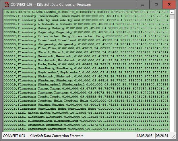
Geodata International - World-wide database of countries with georeferenced towns, municipalities, postal codes and administrative units with WGS84 and UTM coordinates and elevations for geocoding, proximity search, navigation, distance calculation. Often is it necessarily, for an address characteristic, e.g. the place name or the postal code, to establish a local relationship - a georeference. The georeference can be used e.g. to show a...
Read more
- Rate:
- Release Date:07/21/2018
- License:Data Only
- Category:Database
- Developer:Killet Software Ing.-GbR
- Downloads:275
- Size:2.07 Mb
- Price: $165.00
To free download a trial version of Geodata International, click here
To buy software Geodata International, click here
To visit developer homepage of Geodata International, click here
Advertisement
Versions History
| Version | Date Released | Release Notes |
| 7.03 | 27.07.2015 | Germany database updated to release January 2015. 249 country databases total. 15 new country databases with release January 2015 added. 238 country databases on release January 2015 actualized. New country group "Middle East". |
| 6.01 | 21.04.2014 | Database Germany updated to actual date January 2014. Database of Austria updated to actual date September 2013. Databases of 13 countries added. 129 Countries updated on actual date April 2012. Databases sorted by country specific character sets. |
| 5.04 | 02.10.2013 | Database of Austria updated to actual date September 2013. Database Germany and Italy updated to actual date January 2013. Databases of 13 countries added. 129 Countries updated on actual date April 2012. Databases sorted by country specific character sets. |
Screen Shot
Click on a thumbnail for the larger image.
System Requirements
Geodata International requires Win2000, WinXP, Win7 x32, Win7 x64, Windows 8, Windows 10, WinServer, WinOther, Windows2000, Windows2003, Windows Server 2012, Windows Tablet PC Edition 2005, Windows Media Center Edition 2005, WinVista, Windows Vista Starter, Windows Vista Home Basic, Windows Vista Home Premium, Windows Vista Business, Windows Vista Enterprise, Windows Vista Ultimate, WinVista x64, Windows Vista Home Basic x64, Windows Vista Home Premium x64, Windows Vista Business x64, Windows Vista Enterprise x64, Windows Vista Ultimate x64.
Geodata International v.10.05 Copyright
Shareware Junction periodically updates pricing and software information of Geodata International v.10.05 full version from the publisher using pad file and submit from users. Software piracy is theft, Using crack, password, serial numbers, registration codes, key generators, cd key, hacks is illegal and prevent future development of Geodata International v.10.05 Edition. Download links are directly from our publisher sites. Links Geodata International v.10.05 from Bittorrent, mediafire.com, uploadfiles.com, hotfiles.com rapidshare.com, megaupload.com, netload.in, storage.to, depositfiles.com and other files hosting are not allowed. The download file is obtained directly from the publisher, not from any Peer to Peer file sharing applications such as Shareaza, Limewire, Kazaa, Imesh, eDonkey, eMule, Ares, BearShare, Overnet, Morpheus, BitTorrent Azureus and WinMX.
Review This Software
More Geodata International Software
Advertisement
Geodaten International v.6.01
Geodata International - World-wide database of countries with georeferenced towns, municipalities, postal codes and administrative units with WGS84 and UTM coordinates and elevations for geocoding, proximity search, navigation, distance calculation.
LangPad - International Characters
LangPad - International Characters provides an easy way to insert foreign language characters, math, currency, and literary symbols into your WordPad and Notepad text. Click the mouse on a character or symbol in the chart, and it will be inserted into

Tally International Support v.9.0
Tally Support features include Payroll. Tally Payroll is integrated with Accounting to give the user the benefits of simplified Payroll processing and accounting. Tally International Services for your Small business in worldwide.
International Cricket Captain 2010 v.1.0
Take control of your favorite side from the English County, International or Australian Domestic system. You control your team's fortunes. Have you got what it takes to be a world champion?

QQ International v.2.0
Chat and meet with friends from all over the world: beat barriers with QQ International, thanks to HD video calls and real-time chat translation. Create and manage chat rooms with up to 1000 users. Join over 800mil global users today - it's free!
International Cricket Captain v.10.16
International Cricket Captain is back for the fascinatingly poised 2010 season. With up to date competitions, outstandinger realism, and packed with features and stats, Cricket Captain 2010 will once again raise the bar in cricket management gaming.
Geodata Germany v.22.03
The database contain geodata of the Federal Republic of Germany with geo referenced towns, municipalities, town quarters, administrative units, postal codes, telephone preselections, nature areas, landscapes, climatic zones for proximity searches ec.

Portamind International checkers v.1.1
Despite of your skills in International checkers, you will get a worthy opponent on your mobile device.
E-Futures International
E-Futures International is an easy to use application that handles all of the complexities associated with commodity futures trading and order management, from streaming quotes and charts to full communication with our trade desk. Experience one-click

Geodaten International Admin
Geo data international world-wide with towns, town quarters and postal codes. Georeferences as UTM- and geographic coordinates (WGS84) and elevations. Suitable for branch searches, periphery searches and distance computations. Australia, Austria,
LibertyCommerce7 International
LibertyCommerce7 International is management software that is absolutely free. The original idea behind the project was to get our company known outside Italy.
Other products of this developer Killet Software Ing.-GbR

DRAGSENS v.4.01
DRAGSENS Geo Software is used for the exact posi... estimation of the position of a dragged sensor.

Geodata Germany v.22.03
The database contain geodata of the Federal Repu...capes, climatic zones for proximity searches ec.

GeoDLL v.18.24
GeoDLL is a Geodetic Development Kit / Geodetic ...rt, NTv2, HARN, INSPIRE, EPSG, DEM and much more

Graphics4VO DLL v.11.04
Graphics4VO is the graphics interface for the pr... the display, printer, plotter, file and memory.

ORTWIN v.13.02
ORTWIN is a program for the inquiry of localitie...capes, natural units, snow- and wind load zones.

SEVENPAR v.8.01
SEVENPAR calculaties exact parameter sets for th...eference systems for coordinate transformations.

TOPOWIN v.16.00
TOPOWIN is a state-wide register of the German t...ms. It also is a topographic information system.

TRANSDAT v.20.37
TRANSDAT Coordinate Conversion supports thousand...le systems and much more with highest accuracy.